

Archive Record
Images
Metadata
Title |
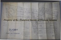
Copy of Map of the Rugby Neighborhood Roanoke |
Dates of Creation |
04/16/1953 |
Scope & Content |
1953 tracing of the December 11th, 1916 map of the Rugby neighborhood in Roanoke, Virginia. The map shpws the planned streets, parcels, and coordinates for the new subdevelopment. The Rugby neightborhood was built by the Rugby Land Corporation in Roanoke. The original map was made by Smith, Bradford, & Co Engineers based in Roanoke. |
Year Range from |
1953 |
Year Range to |
1953 |
Subjects |
Developments, Housing Maps Roanoke (VA) - History Neighborhoods Corporation Engineering & construction Engineering drawings Engineers 1950s Reproductions |
Search Terms |
Rugby Land Corporation Rugby Neighborhood Smith, Bradford & Co Engineers Smith, Bradford & Co Roanoke Map Housing Development Neighborhood Plan Engineering Plan Parcels Plots |
People |
Hildebrand, J.R. Fairfax, R.R. Sheretz, J.S. |
Collection |
Historical Society of Western Virginia |
Imagefile |
101\20241456.JPG |
Number of images |
1 |
Object Name |
Map |
Object ID |
2024.14.56 |
Extent of Description |
Paper, 39.75 w x 26 h in |