

Archive Record
Images
Metadata
Title |
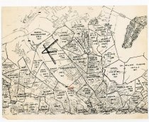
Roanoke Landownership (1748-1807) |
Dates of Creation |
1961-1990 |
Scope & Content |
Map of Roanoke Landownership from 1748-1807 with plots drawn out with the owners name, acreage, and when it was acquire within each plot. |
Year Range from |
1961 |
Year Range to |
1990 |
Subjects |
Maps Land Land measurement Land owner Land titles Lands Plots Ownership |
Search Terms |
Landownership in Roanoke |
People |
Griffith, Methusaleh Griffith, Jmo. Brown Neeley, James Reynolds, Obediah Neeley, Dr. John Patterson, Erwin McClanahan, William Evans, Mark Breckinridge, Robert Craig, Tolliver Mcneal, Neal Evands, Mark Mason, James Walker, Joseph McNeal, John Evans, Nathan Campbell Barnes, Thomas Askins, John Amstrong, William Skillern, George Smith, Francis Gish, David Gish, Christian Fleming, William Christian, Israel Robinson, John Graham, Francis Mills, John Denton, Benjamin Fleming, Leonard McCormick, Daniel |
Collection |
Historical Society of Western Virginia |
Imagefile |
077\2019050661.JPG |
Number of images |
1 |
Object Name |
Map |
Object ID |
2019.05.066.1 |
Extent of Description |
Paper, 8.5w x 11h |