

Archive Record
Images
Metadata
Title |
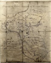
Survey Map of Land Belonging to Thomas & Tasker Tosh |
Scope & Content |
Property survey map of the land belonging to Thomas and Tasker Tosh, approximately 1650 acres. It includes the plantation called "Lone Oak", as it stood at the time of the marriage of Elizabeth Tosh and William Lewis. |
Year Range from |
1740 |
Year Range to |
1812 |
Subjects |
Land surveying Maps Pioneers Property rights Settlements Settlers Survey drawings |
Search Terms |
Lone Oak Roanoke River Tinker Creek Tosh family |
People |
Lewis, William Tosh, Elizabeth Tosh, Jonathan Tosh, Thomas |
Collection |
History Museum of Western Virginia |
Imagefile |
001\195922-2.JPG |
Number of images |
1 |
Object Name |
Map |
Object ID |
1959.2.2 |
Extent of Description |
Single sheet, size 7 3/4" x 9 1/2" |