

Archive Record
Images
Metadata
Title |
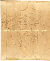
Land survey and division for Jonathon Tosh |
Dates of Creation |
post 1812 |
Scope & Content |
Ink drawing illustrating the division of land, higlighting landmarks, acreage, and other geographical features. The Roan Oak [sic] River runs through the land, left of center. Land is split between Elizabeth Tosh, William Lewis, and Thomas Tosh. Watts Land is written along the bottom right corner beside Tinker Creek. Accession Register states 'Post 1812 after Jonathon Tosh died." |
Year Range from |
1812 |
Year Range to |
1815 |
Subjects |
Land Land grants Land surveying Land subdivision |
Search Terms |
Tosh survey land Watts |
People |
Tosh, Jonathan Tosh, Elizabeth Lewis, William Tosh, Thomas |
Collection |
Historical Society of Western Virginia |
Imagefile |
069\196436.JPG |
Number of images |
2 |
Object Name |
Survey, Land |
Object ID |
1964.36 |
Extent of Description |
9.625 h x 8 w |