Search Term Record
Metadata
Name |
survey |
Related Records
-
View Full Record
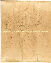
Object appears to be a land survey with the conductors of the survey being listest across the object.
Record Type: Archive
-
Deed - April 12, 1920
Deed made on April 12, 1920, between Octavia E. Wade and W. P. Nunley. The deed is for the Nunley's purchase of land for $500 in Roanoke County - being property formerly owned by P. B. Stephens. Deed is signed by Octavia Wade and witnessed by W. G. Neighbors.
Record Type: Archive
-
Historical Society of Western Virginia Newsletter - May 2000
Historical Society of Western Virginia May 2000 newsletter. Newsletter includes highlights of the Museums and Historical Society activities. The newsletter talks about the museum's May meeting, which focused on the Roanoke Regional Preservation's survey of Roanoke County cemeteries. It also announces the musuems new and renewing members, and includes a calendar of upcoming events.
Record Type: Archive
-
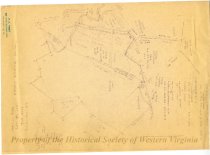
Land survey and division for Jonathon Tosh - post 1812
Ink drawing illustrating the division of land, higlighting landmarks, acreage, and other geographical features. The Roan Oak [sic] River runs through the land, left of center. Land is split between Elizabeth Tosh, William Lewis, and Thomas Tosh. Watts Land is written along the bottom right corner beside Tinker Creek. Accession Register states 'Post 1812 after Jonathon Tosh died."
Record Type: Archive
-
-
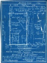
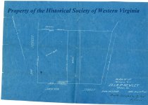
Plat Survey of the property of Estelle K. Kingery - August 25, 1914
Plat survey for the proprety of Ella P. Nunley (although the plan says 'Ella P. Newley) completed by Smith Bradford and Gilbert Engineers. The survey is fairly plan and includes the overall dimensions of the land, and adjoining plots. The lot is bordered by 3rd street at the west, Jackson St at the south, the Wade Lot at the east, and the Pedigo lot at the north.
Record Type: Archive
-
Plat Survey of the property of Estelle K. Kingery - February 21, 1953
Plat survey for the proprety of Estelle K. Kingery in the town of Vinton, completed February 21, 1953. The plat is between Poplar St (formerly 3rd St), Lee Ave (formerly Lee St), 4th St (formerly the old country road), and Jackson St. The plat has a number of notations concerning the land, bulidings, and adjoining property information.
Record Type: Archive