Search Term Record
Metadata
Name |
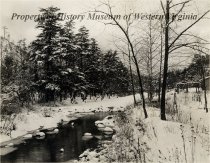
Roanoke River |
Related Records
-
-
-
Bernard's Landing history - n.d.
Narrative concerning Bernard's Landing at Smith Mountain Lake.
Record Type: Archive
-
Bernard's Landing history - n.d.
Narrative concerning Bernard's Landing at Smith Mountain Lake.
Record Type: Archive
-
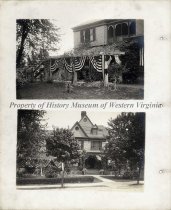
Cocke-Spur view 6 from scrapbook - May 4, 1914
Photographs of the flag draped pergola and front elevation of "Cocke-Spur", the rambling Queen Anne style Orchard Hill residence of Mr. Lucian Hayward Cocke and Sarah Johnson Hagan Cocke, his wife, just prior to the May 4, 1914 reception for Vice President, and Mrs.Thomas R. Marshall. Cocke, a widower with two sons and two daughters, met Sarah Johnson Hagan, a widow with two sons, at The Homestead in Bath County, Virginia. They were married on Oc...
Record Type: Archive
-
-
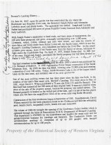
deed - 07/18/1787
This a deed for 250 acres sold by the Commonwealth of Virginia (signed by the Lt. Governor Beverly Randolph) to Richard and Thomas Bandy and Christian Wynard (Vinyard) [the said Richard and Thomas Bandy were assignees of John Hawkins] for one pound five shillings sterling. This tract was located in "Botetourt County on Roanoke and Wolf Creek joining their lands and the land of John Metts, dec'd". The survey was completed on March 21, 1782 and...
Record Type: Archive
-
Deed - August 20, 1822
This deed records the sale of 26 acres of land lying in Botetourt County, Virginia by Stanley Cisson to Jacob Brubaker for $112 and is dated August 20, 1822. The metes and bounds are described and the names of adjacent property owners are mentioned. Early settler Mark Evan signed the deed as a witness.
Record Type: Archive
-
Deed - November 11, 1867
This deed, made November 11, 1867, conveys 86 acres from the estate of William Poage, Sr., to Elijah Poage by certain other heirs of his estate. The names of numerous children and their spouses are mentioned in this deed. Metes and bounds are written. No consideration is named for this transaction.
Record Type: Archive
-
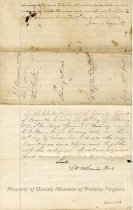
Deed - November 22, 1875
This deed conveys 28 1/4 acres of land in Roanoke County, Virginia from Mathias Agee and his wife, Mary J. Agee, of Bedford County, to William E. Grisso of Roanoke County for a stated consideration of $1. The land was recently surveyed by Thomas A. Jeter, surveyor of Bedford County. Metes and bounds are described.
Record Type: Archive
-
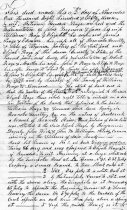
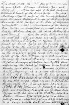
Deed - November 25, 1882
This deed made November 25, 1882 conveys tract numbers 1, 2, and 3 containing 44, 41, and 177 3/4 acres, located in Roanoke County on the Roanoke River from Isaac T. Bandy and his wife Sallie J. Bandy to William Grisso for $3,000. The land originally belonged to Joseph Ducukwiler, deceased, and the Roanoke Circuit Court in the October term appointed a Commision to divide the land among the heirs. Metes and bounds are described.
Record Type: Archive
-
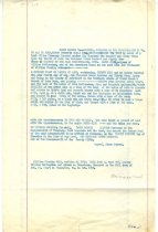
Deeds for Right Of Way - May 11 & May 17, 1892
Deeds of Parcels #6 and #7, belonging to Peyton L. Terry, dated May 11, 1892. Revised deed for Parcel #6 is dated May 17, 1892. Deeds appear to be for the right-of-way for the Roanoke Belt Line. These are typed copies of the original deed.
Record Type: Archive
-
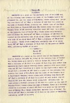
Deposition - June 27, 1769
Deposition of Colonel John Buchanan, certified by and before William Preston, a Justice of Augusta County, on June 27, 1769. Establishes his 1/3 interest in money received for land called "Patton's Bottom" on the north fork of the Roanoke River, sold by executor of Patton's estate to James Bryan, millright, but owned jointly by Patton, Buchanan, and James Campbell.
Record Type: Archive
-
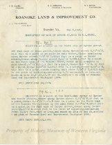
Description of Lots on Spruce Street - May 2, 1891
Legal description of lots on Spruce Street sold to Peyton L. Terry, the first one dated 07/12/1890 and the second one dated 09/12/1890. These deeds are typed copies on a letterhead, "Roanoke Land & Improvement Co."
Record Type: Archive
-
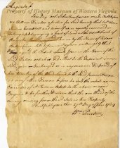
Document - Will - November 27, 1800
A carbon copy of an order, signed by James Monroe, the Governor of Virginia, granting to William Gish, a 39-acre land parcel from the last will and testament of William Fleming, executed in Botetourt County Court in Fincastle, Virginia in October 1795.
Record Type: Archive
-
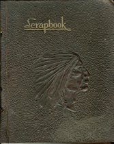
Hunting and Taxidermy scrapbook - 1924
Naturalist, hunting, and taxidermy scrapbook compiled by Michael B. Newman of Roanoke, Virginia. Contains a plethora of photos, newspaper clippings, letters from local colleges, and even a piece of tanned 'human' skin. This scrapbook is a small glimpse into Roanoke in the 1930s, especially as it related to hunting and hunt clubs.
Record Type: Archive
-
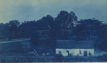
Jefferson Street Bridge - A cyanotype of the Jefferson Street Bridge spanning the Roanoke River, looking towards Roanoke, Virginia.
1967.64.43
Record Type: Photo
-
Land Patent - copy made on 03/20/1821 of original patent issued on September 26, 1790
This is a copy from record by Wm. G. Pendleton, Registrar, Land Office of a land patent from King George II for 253 acres of land lying on a brach of the Roanoke and in 1760 being in Augusta County, Virginia. The person receiving this land was John Mackadoo. The patent was signed by Francis Fauquier, Lt. Governor of the Colony on September 26, 1760.
Record Type: Archive
-
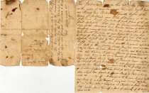
Letter - October 3, 1822
Letter dated October 3, 1822 from Mat Wilson, Cumberland County, Kentucky to Peachy R. Gilmer, in Liberty, Bedford County, Virginia, about his trip from Virginia to Kentucky, mentioning the problems crossing the Roanoke River at several points, problems with his wagons, Abingdon, etc.. The envelope is marked "Burksville, Ky., Oct. 9, 1822."
Record Type: Archive
-