Search Term Record
Metadata
Name |
Rugby Neighborhood |
Related Records
-
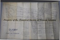
Copy of Map of the Rugby Neighborhood Roanoke - 04/16/1953
1953 tracing of the December 11th, 1916 map of the Rugby neighborhood in Roanoke, Virginia. The map shpws the planned streets, parcels, and coordinates for the new subdevelopment. The Rugby neightborhood was built by the Rugby Land Corporation in Roanoke. The original map was made by Smith, Bradford, & Co Engineers based in Roanoke.
Record Type: Archive
-
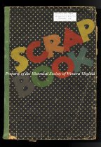
Early Aviation in Roanoke Scrapbook
Soft cover paper scrapbook with the word Scrap Book written diagonally across the front in multi color letters. The scrapbook cover is black with white polka dots and a green spine. There is a note attached to the cover that reads Charles Albert Wade from his flying days at Woodrum Airport in Roanoke, VA 1930's to early 1940's. Scrapbook is filled with glued on photographs of early airplanes, pilots, and newspaper clippings from the 1930's. Ther...
Record Type: Archive
-
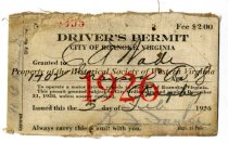
Roanoke City Driver's Permit 1926 - 02/05/1926
1926 Driver's Permit for the City of Roanoke issued to Charles Albert Wade on 02/05/1926. Address: 1702 Grayson Ave, Roanoke. Age: 18. Permit No. 9335. Large 1926 printed in red over the middle of the card. Signed by R.J. Jagler, Supt. of Police. Expires 12/31/1928. Card made of glazed cotton fabric.
Record Type: Archive
-
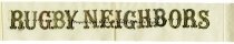
Rugby Neighbors Ribbon - Specific date unknown
White artificial silk ribbon with Rugby Neighbors in gold lettering glued to front. The ribbon has been cut diagonally at the ends. The ribbon relates to the Rugby neighborhood in Roanoke Virginia, built between 1918-1949.
Record Type: Archive