

Person Record
Metadata
Name |
Tosh, Jonathan |
Related Records
-
-
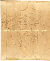
Land survey and division for Jonathon Tosh - post 1812
Ink drawing illustrating the division of land, higlighting landmarks, acreage, and other geographical features. The Roan Oak [sic] River runs through the land, left of center. Land is split between Elizabeth Tosh, William Lewis, and Thomas Tosh. Watts Land is written along the bottom right corner beside Tinker Creek. Accession Register states 'Post 1812 after Jonathon Tosh died."
Record Type: Archive
-
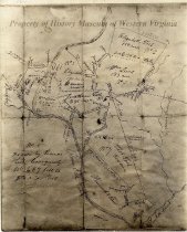
Survey Map of Land Belonging to Thomas & Tasker Tosh
Property survey map of the land belonging to Thomas and Tasker Tosh, approximately 1650 acres. It includes the plantation called "Lone Oak", as it stood at the time of the marriage of Elizabeth Tosh and William Lewis.
Record Type: Archive
-
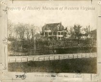
Thomas and Tasker Tosh, Pioneers "on Roanoke" - n.d.
Typescript titled "Thomas and Tasker Tosh, Pioneers "on Roanoke"", [compiled by Miss Margaret Scott], n.d. The paper covers the arrival of two brothers, Thomas and Tasker Tosh to the Roanoke River area, near Goose Creek. They are considered to have been among the first to settle in the Roanoke Valley.
Record Type: Archive
