Search Term Record
Metadata
Name |
Augusta County, Virginia |
Related Records
-
-
-
-
-
Biography of General James A. Walker - 1896
James A. Walker was born in Augusta County, Virginia on August 27, 1832, and was a student at the Virginia Military Institute. After leaving the Institute in 1852 he was employed for two years as a civil engineer on the Covington and Ohio Railroad. He attended law school at the University of Virginia and was located at Pulaski Court House in 1855 as a lawyer. He was elected attorney for Pulaski County. At the time of the John Brown Raid, he began...
Record Type: Archive
-
Black Horse Tavern Notebook - 1935
Notes, copies of correspondence, and plans assembled by P.H. Trout in 1935 regarding Black Horse Tavern. President Andrew Jackson purportedly overnighted at the Black Horse on his journeys between Nashville, Tennessee, and Washington, D.C. Included correspondence to Trout from Ben P. Ainsworth of Lexington, Virginia, places Jackson at the Blackhorse through statements made to Ainsworth by Hezekiah Kyle of Amsterdam, Virginia, who recalled seeing ...
Record Type: Archive
-
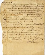
Bond Forms - February 17, 1752
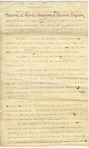
Bond forms used in sale of land owned by James Patton and others. Two were executed: one to John Huggins, February 7, 1752; one to Michael Daugherty and William Cleghorn, February 17, 1753, unsigned. Several unused slightly different versions are included in this booklet.
Record Type: Archive
-
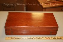
Boxed Compass
This surveying instrument was in general use by surveyors during the last half of the 18th century, probably around 1780. The box is wooden with brass hooks and eyes to secure the top shut. The brass instrument has a needle that gives the direction, degree, and adjustment to level the two levelers. Accurate surveys were critical in establishing and defending claims of land owndership. Andrew Lewis was a surveyor in Augusta County for over thirtee...
Record Type: Archive
-
-
-
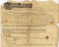
Deed - February 7, 1763
Indenture between Joseph McDonald and William Preston for the sale of 142 acres of land that was part of a 2,475 acre patent and was adjacent to the lands of the heirs of Edward McDonald. The document was dated February 7, 1763. Consideration: five shillings for the property plus a quit rent of "one peppercorn on Lady-Day next if lawfully demanded". Witnesses: Robert Breckinridge, Samuel McKnab, William Anderson, John Buchanan, Lettice Breckenrid...
Record Type: Archive
-
Deposition - June 27, 1769
Deposition of Colonel John Buchanan, certified by and before William Preston, a Justice of Augusta County, on June 27, 1769. Establishes his 1/3 interest in money received for land called "Patton's Bottom" on the north fork of the Roanoke River, sold by executor of Patton's estate to James Bryan, millright, but owned jointly by Patton, Buchanan, and James Campbell.
Record Type: Archive
-
-
-
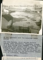
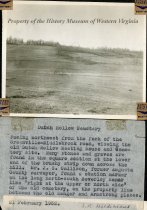
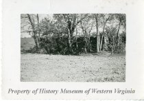
Harnsberger-Hunter Cemetery - J.R. Hildebrand's notation on back of photo is as follows: "Harnsberger-Hunter Cemetery on Christian's Creek in Augusta County. See J.R.H. map of Devision of Harnsberger Estate. (J.R. Hildebrand)"
1990.69.1151b
Record Type: Photo
-
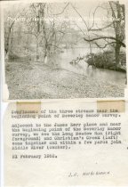
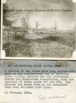
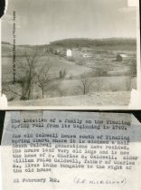
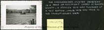
Harnsberger-Hunter Cemetery - The Harnsberger-Hunter Cemetery in a bend of Christians Creek in Augusta County. A Spanish coin was ploughed up in this bottom, whose date was prior to the Revolutionary War.
1990.69.1151a
Record Type: Photo
-
-
-
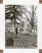
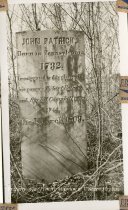
John Fitzpatrick headstone - John Fitzpatrick cemetery stone with 1782 date of death clearly shown.
1990.69.1146e
Record Type: Photo
-
Land Agreement - November 9, 1776
Land agreement dated November 9, 1776 (or is it 1778?) between William Preston and the heirs of George Robinson who were Samuel and James Robinson. Witnesses were Thomas Lewis, Hugh Crockett, and Andrew Wood.
Record Type: Archive