Search Term Record
Metadata
Name |
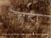
Blue Ridge Parkway |
Related Records
-
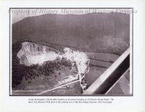
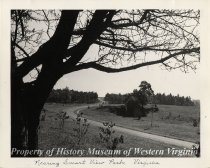
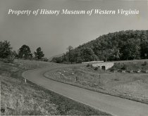
1958 Aerial Photo of Rockydale Quarries - A black and white aerial photograph of Rockydale Quarries at its current location on Old Rocky Mount Road. The photo was taken in 1958, prior to the construction of the Blue Ridge Parkway.
2006.31.4
Record Type: Photo
-
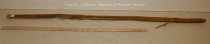
Blue Ridge Heritage Walking stick - Wooden walking stick with leather strap and rubber tip. "Blue Ridge Heritage Walking Stick" on the side.
1998.08.44
Record Type: Object
-
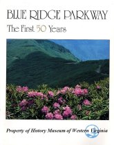
Blue Ridge Parkway - The First 50 Years - 1985
Book cover for "Blue Ridge Parkway - The First 50 Years," a pictoral history book published in 1985 by longtime park historian Harley E. Jolley. Reproduced from the original in the possession of Kaye Anne Davis Aikins.
Record Type: Archive
-
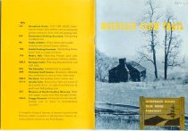
Booklet - 1959(revised)
A 16-page booklet in soft-cover titled "Mountain Farm Trail" located at Humpback Rocks on the Blue Ridge Parkway published (revised edition) by the Eastern National Park and Monument Association under the U.S. Department of the Interior. Humpback Rocks is a massive greenstone outcrop near the peak of Humpback Mountain with a summit elevation of 3,080 feet. The rock is so named for the visual effect of a "hump" it creates on the western face of t...
Record Type: Archive
-
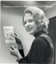
Connie Hildreth - A black and white photograph of Connie Hildreth holding a Roanoke Valley travelers brochure featuring the Blue Ridge Parkway.
1990.69.891
Record Type: Photo
-
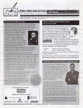
Historical Society of Western Virginia Newsletter - November/December 2010
Historical Society of Western Virginia November/December 2010 newsletter. Newsletter includes highlights of the Museums and Historical Society activities. The newsletter talks about the museum's History is Served luncheon with Jon Meechum, Fantasyland, Breakfast with Santa, November's Kegley Lecture with David Hill, December's Kegley lecture with Vaughan Webb on Shaping Appalachian Music, a Richmond day trip, and news from the Virtual Museum a...
Record Type: Archive
-
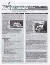
Historical Society of Western Virginia Newsletter - September/October 2010
Historical Society of Western Virginia September/October 2010 newsletter. Newsletter includes highlights of the Museums and Historical Society activities. The newsletter talks about the museum's two separate upcoming tours to the Blue Ridge Parkway and Danville, as well as upcoming exhibits and events, including the Flood of 85 exhibit, War & Pieces - a lecture by Navona Hart, a lecture on tips for finding, documenting, and protecting cemeteri...
Record Type: Archive
-
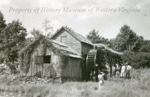
Mabry Mill - Black and photograph of the Roanoke Appalachian Trail Club at Mabry Mill on the Blue Ridge Parkway in 1947.
2011.50.06
Record Type: Photo
-
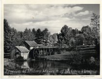
Mabry Mill - Photograph of Mabry Mill on the Blue Ridge Parkway. Lower portion of photograph has "Mabry Mill" and "Stephenson".
1990.69.003
Record Type: Photo
-
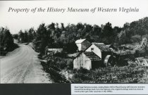
Mabry Mill - Visitors to Mabry Mill in Floyd County will discover restorers moved the building back from the Blue Ridge Parkway as the original building was too close to the roadway as construction got underway in the 1930s.
1990.69.1124
Record Type: Photo
-
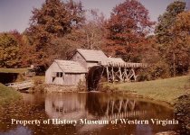
Mabry Mill in the fall - Color photograph of Mabry Mill on the Blue Ridge Parkway, in the fall.
1990.69.004
Record Type: Photo
-
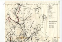
Map of Botetourt County Primary and Secondary Highway Systems - January 1, 1965
An 18" x 23" Commonwealth of Virginia, Department of Highways map depicting the primary and secondary highway systems in Botetourt County, Virginia. The map, dated January 1, 1965, is priced at 10 cents. The front has an illustration of the seal of the Commonwealth, and lists "District Engineer, Salem, Virginia" and "Resident Engineer, Salem, Virginia". The map shows the location of Botetourt County to the rest of the counties in the Commonwealth...
Record Type: Archive
-
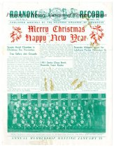
"Merry Christmas Happy New Year" - December 1951
Vol. IV No., 11 of the Roanoke Record, December 1951, published monthly by the Roanoke Chamber of Commerce. The holiday edition showcases the Santa Claus Bowl and the players
Record Type: Archive
-
-
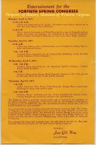
Program - April 3 through 7, 1967
A one-page program titled "Entertainment for the FORTIETH SPRING CONGRESS." This program outlines lunches, banquets, day-trips, etc., hosted by the ladies associated with Gill Memorial Foundation The events occurred at Hotel Roanoke in 1967.
Record Type: Archive
-
-
-